
 Mijn Studiezaal (inloggen)
5129 Collectie kaarten en tekeningen van het Streekarchief Langs Aa en Dommel, ca. 1550-ca. 1985
Inventaris
Kaarten met nummer 3

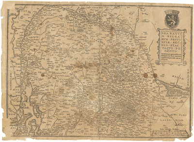
3G01 Brabantiae Belgarum Provinciae Recens Exactaque Descriptio: Recente en Nauwkeurige Beschrijving van de Provincie Brabant
In 1999 two small woodcut maps of the 'Southern Netherlands' (between 1577 and 1585) and of the 'Duchy of Brabant' (after 1577) were discovered. Both undated maps were signed by Antonius van Leest and printed at The Golden Hand ('in Manu Aurea') in Antwerp. Antonius van Leest (about 1545 - after 1592), a many-sided wood-cutter and printer, was active in the offices of Plantin/Plantijn and of Bernard van den Putte. Around 1577 he bought the printing office of Nicolas van Asse, the brother-in-law of Van den Putte. In1585 he fled to the northern Netherlands, where he died probably around 1592. In 1595 the printing office was sold by his widow [bron: Caert-Tresoor.nl; H. vd. Heijden]. , c. 1580
In 1999 two small woodcut maps of the 'Southern Netherlands' (between 1577 and 1585) and of the 'Duchy of Brabant' (after 1577) were discovered. Both undated maps were signed by Antonius van Leest and printed at The Golden Hand ('in Manu Aurea') in Antwerp. Antonius van Leest (about 1545 - after 1592), a many-sided wood-cutter and printer, was active in the offices of Plantin/Plantijn and of Bernard van den Putte. Around 1577 he bought the printing office of Nicolas van Asse, the brother-in-law of Van den Putte. In1585 he fled to the northern Netherlands, where he died probably around 1592. In 1595 the printing office was sold by his widow [bron: Caert-Tresoor.nl; H. vd. Heijden]. , c. 1580
Reden geen uitleen:
Scans beschikbaar
Beschrijving:
Brabantiae Belgarum Provinciae Recens Exactaque Descriptio: Recente en Nauwkeurige Beschrijving van de Provincie Brabant
In 1999 two small woodcut maps of the 'Southern Netherlands' (between 1577 and 1585) and of the 'Duchy of Brabant' (after 1577) were discovered. Both undated maps were signed by Antonius van Leest and printed at The Golden Hand ('in Manu Aurea') in Antwerp. Antonius van Leest (about 1545 - after 1592), a many-sided wood-cutter and printer, was active in the offices of Plantin/Plantijn and of Bernard van den Putte. Around 1577 he bought the printing office of Nicolas van Asse, the brother-in-law of Van den Putte. In1585 he fled to the northern Netherlands, where he died probably around 1592. In 1595 the printing office was sold by his widow [bron: Caert-Tresoor.nl; H. vd. Heijden].
In 1999 two small woodcut maps of the 'Southern Netherlands' (between 1577 and 1585) and of the 'Duchy of Brabant' (after 1577) were discovered. Both undated maps were signed by Antonius van Leest and printed at The Golden Hand ('in Manu Aurea') in Antwerp. Antonius van Leest (about 1545 - after 1592), a many-sided wood-cutter and printer, was active in the offices of Plantin/Plantijn and of Bernard van den Putte. Around 1577 he bought the printing office of Nicolas van Asse, the brother-in-law of Van den Putte. In1585 he fled to the northern Netherlands, where he died probably around 1592. In 1595 the printing office was sold by his widow [bron: Caert-Tresoor.nl; H. vd. Heijden].
Datering:
c. 1580
Auteur:
Onbekend
Uitgever:
Anthonis van Leest te Antwerpen
Afmeting:
38 x 51 cm
Schaal:
Onbekend
Vindplaats origineel:
Den Bosch
Vorm:
Gedrukt, opgeplakt op karton
orientatie:
Oosten boven
Opmerkingen:
RESTAUREREN. Noordgrens Tiel, Rotterdam, westgrens Tholen, Dendermonde, zuidgrens Namen, oostgrens Aken, Venlo
1 gedigitaliseerd